Maidenhair Falls / Cabin Falls
"Avoiding danger is safer in the long run than outright exposure. Life is either a daring adventure or nothing" - Helen Keller


Difficulty - ✹✹✹✹ (out of 5)
Scenic Beauty - ✰✰✰✰✰ (out of 5)
Directions - click here
I didn't have any real expectations when we decided to hike to Cabin and Maidenhair falls. The pictures in Tim Ernst' waterfall book looked 'ok' but nothing spectacular and we simply went because the weather was nice and we wanted to get out of the house after another week of covid-19 quarantine. It was a pretty sure bet that since this isn't viewed as a 'popular' waterfall and it is a bushwhack hike that we wouldn't encounter any others and could maintain our social distance. Maybe it was just the low expectations but all I can say is 'wow'. I was blown away by this place and so glad we made the journey. This is a hike where it's best to use GPS; not just to find the falls but also the parking area. In general the parking area is just off highway 7 North of Dover in Pope County. The coordinates for the parking area are: 35.56781, -93.06618. Cabin Falls: 35.56936, -93.06311 and for Maidenhair: 35.56613, -93.06165.
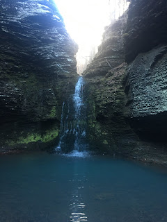
The scoop - There are no real landmarks at the parking area except to note that you'll park under some electric lines in a utilities right of way. There is a picture of the parking area below. There are two ways to get to the falls. One is to hike directly to each one and then backtrack to the parking area and then go to the other one. The other is to go to Cabin Falls first, then continue on a loop to Maidenhair before finding your way back to the parking area. The loop is about 1.5 miles total length so not too far. We did the loop and very happy that we did because there are several other nice, unnamed waterfalls that you encounter in this loop. To do this, proceed north under the power lines until you get to the bottom of a small ravine (about 100 yards). From that point go into the woods and basically follow the ravine. There had not been much rain prior to our trip there so we didn't expect much water but after about 20-30 yards into the woods we came across an underground spring feeding the creek so I suspect there is a water flow most of the year here. The trek to cabin falls is probably no more than 1/4 mile past this point and you come across it quite suddenly as the terrain doesn't really reveal the dropoff too far in advance. The rocks at the top of the waterfall are very slick and we had to restrain our dog Huckleberry from getting too close to the edge. While facing the waterfall, the best route to the bottom will be on your left and you'll have to wind your way down carefully as the ground was quite slick. I can't say that Cabin Falls is particularly impressive from a pure waterfall standpoint but the layers of rock are very interesting from a geologic point of view and the falls does not have a carved, spout like dropoff but rather a sheer, straight edge. From there, you simply follow the creek until it intersects with another tree about 1/4 mile downstream. Along the way you'll encounter seemingly waterfall after waterfall, each of them unnamed but all equally impressive. Our trip was in early April so the foliage on the trees was in full bloom and it gave the area a dense, jungle feel. However if you stay on the stream, the trees and bushes do not present a problem. It's gets progressively more difficult from a climbing and boulder scrambling perspective so we got more of a workout than expected for such a short hike. Anyway, as previously mentioned, you'll continue until the stream you are on converges with another to form a sort of 'V' formation. Here, you'll reverse course up the new stream until you reach Maidenhair. But first you'll encounter lower-Maidenhair falls which is a beautiful two tier waterfall about 100 yards in advance of the main falls. Upper Maidenhair is also a two tier waterfall with the lower cascade splitting off into two distinct streams of water and, to me, resembles a young girls face with her long hair spilling off to each side. I don't have any idea if this is how the water fall got its' name but that was my impression. We were quite tired at this point and rested for a few minutes before beginning the journey back to the parking area. At this point it is extremely helpful to have GPS because the rest of the trek is a complete bushwhack back to the parking area. There are no landmarks and you generally go due west to get back to highway 7. Even if you don't have gps, a good compass will get you back to the highway since you can't miss it if you head due west but gps is highly recommended.
Final Thoughts - The waterfalls on this hike aren't spectacular. The hike isn't the toughest or longest. It's not the most remote place. But the combination of all the elements creates a truly amazing hiking experience. I can't say enough how much I recommend that you do the loop rather than the out-and-back for each waterfall because of the experience of all the smaller falls and bluffs that you encounter. This is a strenuous, although short hike so I don't recommend small kids and it's certainly not for anyone with mobility issues or with poor stamina. But I highly, highly recommend this hike to anyone with an adventurous spirit.
---------------------------------------------------------------------------------------------------
Trailhead Pic

---------------------------------------------------------------------------------------------------


Comments
Post a Comment