Mt Nebo - Rim Trail
"Think of all the beauty still left around you and be happy" - Anne Frank
This is a tale of two hikes. The north and western sides of the rim are relatively flat with broad panoramic views of the valley below. The southern and eastern sides are rocky and mountainous with interesting rock formations and sheer drops in some places. This 3.2 mile hike can be found in Mt Nebo state park near Dardanelle, Arkansas.
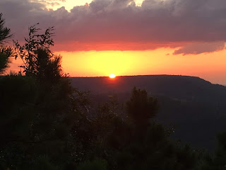
Inside Info - The trip up Mt Nebo on state highway 155 is where the adventure begins as there are numerous sharp switchbacks that require your full attention behind the wheel. There are several signs that say trailers over 24' are not allowed and quite frankly, I don't see how anything larger than a 10' trailer could navigate those sharp turns successfully. Anyone that can pull a 24' trailer up that mountain would be quite the magician. The rim trail is aptly named and traverses the entire circumference of the mountain top. While there is an official trailhead start, you can really start at any point you like and you'll end up where you parked. We chose to start at a place called Sunset Point because we wanted to wait to catch a glimpse of the sunsets we had heard so much about. As previously mentioned, this is truly a tale of two hikes (with apologies to Dickens) because the terrain varies so much from one end to the other. The first half mile or so from our starting point was flat and open with an open view of mountains on the western horizon. You can even see all the way to Mt Magazine (which is about 35 miles away). It is said that on a clear day you can see 100 miles of the Arkansas River (or 50 miles each direction) in the valley below. Continuing on the path you'll come across old CCC camp building ruins from when the state park was established in the early 1900's. Along the way you'll also hike past rental cabins and even homes on top of the mountain so this is not considered a remote destination in any sense of the word. Once you reach the southern end of the rim, the terrain quickly changes to rocky cliffs and rock formations reminiscent of what you'd find in Devil's Den. once you get to the southeastern end of the mountain you'll reach sunrise point and while we didn't observe the sunrise that day, the pics I've seen make it something that I'll eventually want to experience first-hand. The 3.2 mile distance is fairly moderate but there are a couple of steep climbs that will leave most people at least a little winded once you arrive back near the visitors center and campground. We completed the hike about 30 minutes before sunset and that gave us time to hydrate and find a good place to sit and wait for sunset. And oh my what a view the mountain gave us to watch the sun slowly sink into the western horizon and turn the sky into a beautiful display of orange, pink and purple. It was truly an amazing site and someday I would like to rent a cabin and catch both the sunrise and sunset in the same day.
Final Word - This was a great experience that exceeded my expectations and I highly recommend it to everyone. Anyone with moderate fitness and balance can navigate the rim. The trail does take you close to some large drops but again, just a little bit of care will prevent any major accidents but do keep a close eye on pets and little ones. I'll take this moment to give a shout-out to the Arkansas Dept of Parks and Tourism because they do a great job of making the trails easy to navigate while taking care to preserve the natural beauty of these areas. And best of all, there are no fees required to use the trails in the parks.
----------------------------------------------------------------------------------------------------
Trailhead Pic

----------------------------------------------------------------------------------------------------


Difficulty - ✹✹✹ (out of 5)
Scenic Beauty - ✰✰✰✰✰ (out of 5)
Directions - Click Here
This is a tale of two hikes. The north and western sides of the rim are relatively flat with broad panoramic views of the valley below. The southern and eastern sides are rocky and mountainous with interesting rock formations and sheer drops in some places. This 3.2 mile hike can be found in Mt Nebo state park near Dardanelle, Arkansas.
Inside Info - The trip up Mt Nebo on state highway 155 is where the adventure begins as there are numerous sharp switchbacks that require your full attention behind the wheel. There are several signs that say trailers over 24' are not allowed and quite frankly, I don't see how anything larger than a 10' trailer could navigate those sharp turns successfully. Anyone that can pull a 24' trailer up that mountain would be quite the magician. The rim trail is aptly named and traverses the entire circumference of the mountain top. While there is an official trailhead start, you can really start at any point you like and you'll end up where you parked. We chose to start at a place called Sunset Point because we wanted to wait to catch a glimpse of the sunsets we had heard so much about. As previously mentioned, this is truly a tale of two hikes (with apologies to Dickens) because the terrain varies so much from one end to the other. The first half mile or so from our starting point was flat and open with an open view of mountains on the western horizon. You can even see all the way to Mt Magazine (which is about 35 miles away). It is said that on a clear day you can see 100 miles of the Arkansas River (or 50 miles each direction) in the valley below. Continuing on the path you'll come across old CCC camp building ruins from when the state park was established in the early 1900's. Along the way you'll also hike past rental cabins and even homes on top of the mountain so this is not considered a remote destination in any sense of the word. Once you reach the southern end of the rim, the terrain quickly changes to rocky cliffs and rock formations reminiscent of what you'd find in Devil's Den. once you get to the southeastern end of the mountain you'll reach sunrise point and while we didn't observe the sunrise that day, the pics I've seen make it something that I'll eventually want to experience first-hand. The 3.2 mile distance is fairly moderate but there are a couple of steep climbs that will leave most people at least a little winded once you arrive back near the visitors center and campground. We completed the hike about 30 minutes before sunset and that gave us time to hydrate and find a good place to sit and wait for sunset. And oh my what a view the mountain gave us to watch the sun slowly sink into the western horizon and turn the sky into a beautiful display of orange, pink and purple. It was truly an amazing site and someday I would like to rent a cabin and catch both the sunrise and sunset in the same day.
Final Word - This was a great experience that exceeded my expectations and I highly recommend it to everyone. Anyone with moderate fitness and balance can navigate the rim. The trail does take you close to some large drops but again, just a little bit of care will prevent any major accidents but do keep a close eye on pets and little ones. I'll take this moment to give a shout-out to the Arkansas Dept of Parks and Tourism because they do a great job of making the trails easy to navigate while taking care to preserve the natural beauty of these areas. And best of all, there are no fees required to use the trails in the parks.
----------------------------------------------------------------------------------------------------
Trailhead Pic

----------------------------------------------------------------------------------------------------


Comments
Post a Comment